Jantar Mantar, Jaipur
kjohri | Aug 25, 2011 | Comments 0
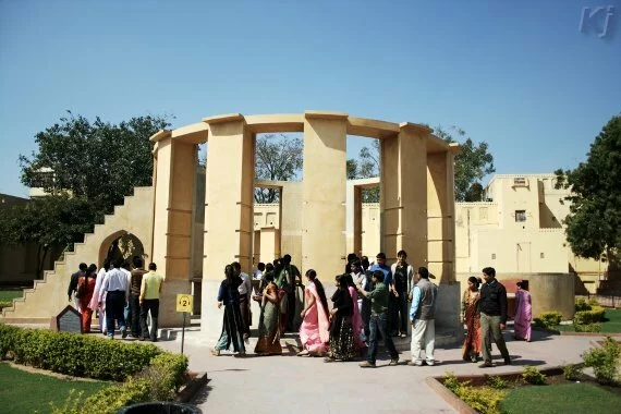
Jantar Mantar at Jaipur is an observatory with architectural instruments for astronomical measurements and observations. Jantar comes from the word Yantra, which means an instrument. Mantar means formulae or calculations. So Jantar Mantar effectively means instruments and underlying formulae and calculations
. Jantar Mantar at Jaipur is a UNESCO World Heritage Site.
Jantar Mantar was built by Maharaja Sawai Jai Singh II (1688-1743), who became the ruler of Amber at the age of 11 after his father’s death. Maharaja Jai Singh had a great interest in mathematics, architecture and astronomy. He built five Jantar Mantar’s in the cities of Delhi, Jaipur, Mathura, Varanasi and Ujjain during the years, 1724-1735. Of these, Jantar Mantar at Jaipur is the biggest and the best preserved. The city of Jaipur is named after Maharaja Sawai Jai Singh.
ELEMENTARY ASTRONOMY
Since Jantar Mantar is about astronomical observations, it is worthwhile to do a quick recap of astronomy terms and some definitions.
Great Circle
A great circle is the intersection between a sphere and a plane passing through its center. A great circle divides a sphere into two hemispheres.
Celestial Sphere
The celestial sphere is an imaginary sphere of arbitrary large radius and is concentric with the Earth. Earth’s equator and the axis passing through the poles projected outwards gives celestial equator and the celestial north and south poles. It can be said that the celestial sphere is the view of the Universe from the Earth.
The celestial sphere is fixed and does not rotate with the Earth.
Meridian
A meridian at any point on Earth is the great circle of celestial sphere passing through the north point on the horizon, the zenith, the south point on the horizon and the nadir.
Declination and right ascension
Declination and right ascension are the two coordinates of any object on the celestial sphere. Declination is similar to the latitude. Declination is measured as the angle a celestial object makes north or south of the celestial equator. The declination of objects on the celestial equator is zero. The declination of objects on the celestial north pole is +90 degrees and that of objects on the celestial south pole is -90 degrees.
Right ascension is similar to the longitude. Right ascension is the angle measured in the east direction, with the first point of Aries being the zero point of right ascension. The first point of Aries is the point on the celestial sphere where the Sun crosses the celestial equator during the March equinox. Right ascension is measured in hours, minutes and seconds, with 24 hours corresponding to 360 degrees. So the right ascension would vary from 0 to 23 hours, 59 minutes and 59.9 (recurring) seconds.
Horizontal coordinate system
In the horizontal coordinate system, the plane containing the horizon is the fundamental plane. It divides the celestial sphere into two hemispheres. The pole of the upper sphere is called the zenith. The pole of the lower sphere is called the nadir. Of course, the lower sphere is not visible to an observer, as the Earth comes in between. The coordinates are,
Altitude
The altitude, or elevation, is the angle between the observer and the celestial object, measured vertically. It is between 0 and 90 degrees.
Azimuth
The azimuth is the angle measured along the horizon, starting from the north direction and going towards east towards the projection of the object on the fundamental plane. In other words, the azimuth is measured on the horizontal fundamental plane. We project the object on the fundamental plane. The azimuth is the angle between the north direction and the object's projection on the fundamental plane, measured towards east.
Zenith distance
Zenith distance is the complement of the altitude. That is, it is (90 – altitude) degrees. It is the angle measured from the zenith to the object.
Earth’s rotation
The Earth rotates about its axis once in about 23 hours 56 minutes and 4.1 seconds. Since the Earth is also orbiting the Sun, it takes about another 3 minutes 56 seconds for the Earth to rotate before the Sun appears at the same place as it was a day back. The Earth rotates towards east. If an observer stations himself or herself in space above the North Pole and looks at the Earth, it would appear to rotate counterclockwise. Similarly, if the observer was stationed in space above the South Pole and looked at the Earth, the Earth would appear to rotate clockwise. The Earth’s speed due to rotation at equator is about 1670 km/hr. At any other point, the speed due to rotation is 1670 km/hr multiplied by the cosine of the latitude of that place. The speed due to rotation at the North and South Poles is zero.
Earth’s orbit
Earth's orbit around the Sun
The earth revolves around the Sun, covering a distance of about 940 million kilometers in about 365.256 days. The fraction explains the need of an additional day in leap years. The speed of Earth in orbit is about 108,000 km/hr. Seen from space a few million kilometers above the North Pole, the Earth revolves round the Sun in the counterclockwise direction. Earth’s orbit around the Sun is elliptical, although the eccentricity of the ellipse is very small, about 0.0167. The distance between the Earth and the Sun varies during a year. The Earth is said to be in perihilion when it is at periapsis, that is, closest to the Sun. This occurs around January 3rd and the distance of Earth from the Sun is about 147 million kilometers. Similarly, the Earth is in aphelion, when it is at apoapsis, that is, farthest from the Sun. This happens around July 3rd and the distance is about 152 million kilometers.
Ecliptic plane
The ecliptic plane is the plane containing the Earth’s orbit around the Sun. Significantly, the Earths axis is not perpendicular to the Ecliptic plane. The Earth’s equatorial plane projected outward is the celestial equatorial plane and is perpendicular to the Earth’s axis. The angle between the ecliptic plane and the celestial equatorial plane is 23.5 degrees.
Ecliptic
As mentioned above the Earth orbits around the Sun in a year’s time. If we project the line joining the Earth and the Sun on the celestial sphere behind the Sun, we get the ecliptic, the apparent path of the Sun on the celestial sphere during the year. Or, what is the same thing, we project the ecliptic plane to intersect the celestial sphere. The intersection of the celestial sphere by the the ecliptic plane is the ecliptic.

The Earth, celestial sphere and the ecliptic
The seasons
The ecliptic is path of the Sun during year as seen from the Earth and the ecliptic plane is inclined to the celestial equatorial plane by about 23.5 degrees, the Sun’s declination (angle between the Sun and the celestial equator) varies during the year. The Sun’s declination is zero on March 21st and September 23rd. These are the two equinoxes during the year, when the Sun is in the celestial equatorial plane. On March 21st, the Sun’s declination is zero. After this, the declination increases north and reaches a maximum of +23.5 degrees on the June 21st solstice. After June 21st solstice the Sun’s declination decreases and becomes zero on September 23rd equinox. After September 23rd equinox, the declination increases south and reaches -23.5 degrees on the December 21st solstice. After December 21st solstice, the declination increases north and becomes zero on the March 21st equinox.
The variation of Sun’s declination gives us the seasons on the Earth. During the June 21st solstice, the north pole is tilted towards the Sun and the northern hemisphere gets more sunlight. The southern hemisphere gets lesser sunlight and the south pole does not get any sunlight at all. It is summer in the in the northern hemisphere and winter in the southern hemisphere. During the December 21st solstice, the situation is simply reversed. Now, the south pole is tilted towards the Sun and the southern hemisphere gets more sunlight. The northern hemisphere gets less sunlight and the north pole does not get any sunlight at all. It is summer in the southern hemisphere and winter in the northern hemisphere. During the equinoxes the Sun is at the celestial equator and both hemispheres get equal sunlight. During the March equinox, it is spring in the northern hemisphere and autumn in the southern hemisphere. And during the September equinox, its autumn season in the northern hemisphere and spring in the southern hemisphere.
Zodiac
The ecliptic serves as the center line for a region 9 degrees on both side of ecliptic, giving a elliptical belt like region called the zodiac. The zodiac is divided into 12 parts, each spanning a longitude of 30 degrees. Each part has a constellation of stars and is named after one of the 12 zodiac signs, viz., Aries, Taurus, Gemini, Cancer, Leo, Virgo, Libra, Scorpio, Sagittarius, Capricorn, Aquarius and Pisces.The Sun takes a month to cover each of these signs along the ecliptic.
Sundial
One very simple, popular and intuitive instrument is the sundial. A sundial has a gnomon, which is the raised part of sundial and casts a shadow on a marked scale underneath. The leading edge of gnomon is called the style. The shadow of the style on the scale below gives the time of the day. The style must be parallel to the Earth’s axis. To ensure this, the style must make an angle with the horizontal equal to the latitude of the place where the sundial is located. As the style is parallel to the Earth's axis, its shadow from sun rays at a given time is in the same direction throughout the year. The changes in sun's declination during the year only results in variation of the length of the shadow; the direction of the shadow remains constant all through the year.
Laghu Samrat Yantra (Small Sundial)
The walls make the gnomon, the upper edge of the walls making an angle of 27 degrees with the horizontal, which is the latitude of Jaipur. The scales are made of marble. The shadow of the gnomon on the scale gives the local time.
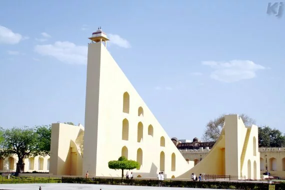
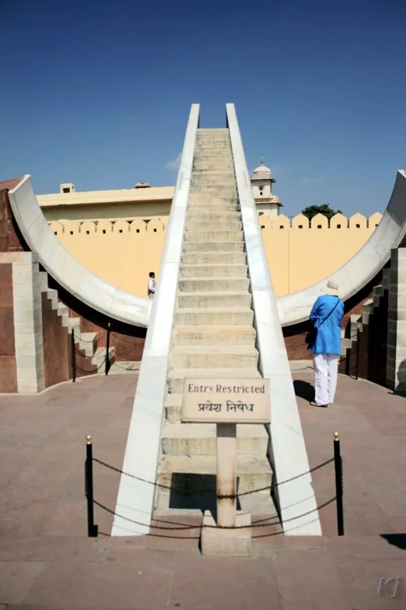
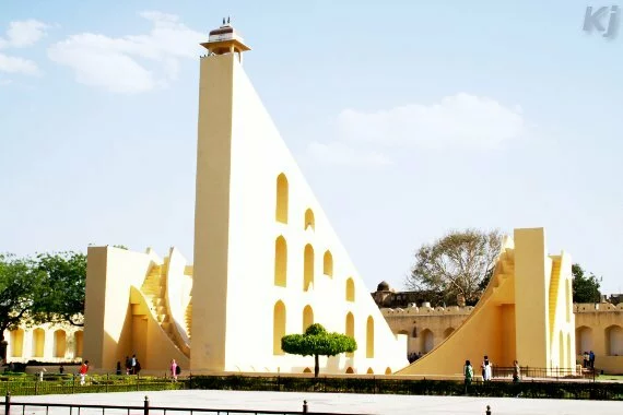
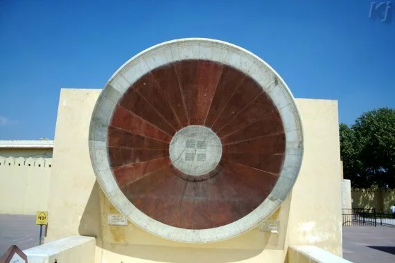
Samrat Yantra
Samrat Yantra, a gigantic sundial, is the largest sundial in the world. The height of gnomon is 27 meters and the base length is about 45 meters. The radius of each quadrant of scale is about 15 meters. The size of Samrat Yantra is such that it has a very high resolution of time measurement. It can give Jaipur's local time to an accuracy of 2 seconds.
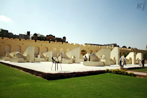
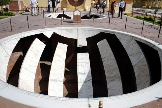
Rashivalya Yanta
Rashivalya Yanta is a collection of twelve zodiac sign instruments, one for each sign of the zodiac. These instruments are used to measure celestial latitude and longitude of celestial objects. Each instrument has a gnomon and the two quadrants. The geometry of gnomon differs for each instrument. Depending upon the current zodiac sign the relevant instrument can be used. At that time, the gnomon of the concerned instrument points to the ecliptic pole and celestial latitude and longitude of a celestial object in the zodiac sign can be measured.
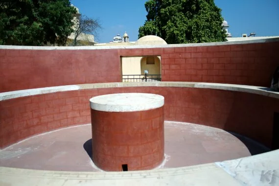
Ram Yantra
Ram Yantra is used to measure altitude and azimuth of celestial objects.There are two cylinders, each with longitudinal gaps. The gaps are there so that one can view the instrument easily. Where there is a gap in one cylinder, there is solid material at that place in the other. So the two cylinders complement each other, and together, they make a single instrument.
Digansha Yantra
The Digamsa Yantra, or Azimuth Circle, is used for measuring the azimuth of celestial objects.
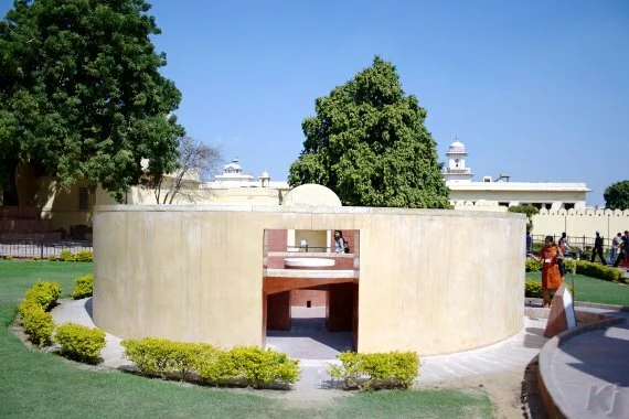
Narivalaya Yantra
Narivalaya (Nadivalya) Yantra is an equatorial sundial.There are two dials, one facing north and the other facing south, both parallel to the equatorial plane. When the sun is in the northern hemisphere, between the March equinox and the September equinox, the dial facing north gets sunlight. There is a slot in the center of the dial where a small rod (gnomon) is placed. The slot for the rod is such that it becomes perpendicular to the dial and becomes parallel to the Earth's axis. The local time is read by seeing the shadow of the rod on the dial. Similarly, between the September equinox and the March equinox, the dial facing south gets sunlight and the local time can be read in a similar manner.
Kapali Yantra
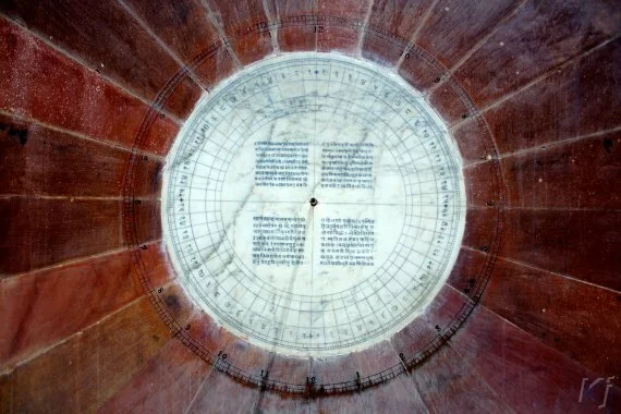
These are two bowl shaped hemispheres with the map of the Universe (celestial sphere) engraved. Two wires are put along the diameters of the circle at the edge of the instrument. These wires are at right angle to each other and the projection of the point of intersection gives the position of Sun along with other celestial objects. Normally, we can either the Sun or the stars in the sky. But by this instrument we can know the position of Sun vis-a-vis stars engraved inside the instrument.
Jai Prakash Yantra
Jai Prakash Yantra is a refinement of Kapali Yantra. The idea is to see the position of Sun in the sky. There are two hemispherical bowls, each representing the sky above. There are recesses in the bowls to let observers get close to the markings. The bowls are complementary, where there is a recess in one, there is solid marble with markings in the other. So at one time, one has to refer to the correct bowl. The position of sun is projected by the shadow of a cross wire placed along at two diameters of a bowl and at right angles to one another. Each bowl is the reflection of the sky above and the projection of the center of cross wire gives the position of Sun.
Krantiwritta Yantra
Krantiwritta Yantra has two brass circles, pivoted with an angle of 23.5 degrees between them. The base circle is parallel to the celestial equatorial plane, while the outer circle is parallel to the ecliptic. The outer circle can be rotated and aligned to the celestial objects. With this instrument, celestial latitude and longitude of a celestial object can be found.
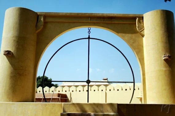
Unnantasha Yantra
Unnantasha Yantra is used for measurement of altitude of celestial objects.
Dakshinobhitti Yantra
The instrument is embedded in a wall placed along the local meridian. It is used for measuring the altitude of celestial objects as these objects cross the local meridian.

Random Quote: Amazing quotations